Engineering Surveying Services Across Australia

Engineering surveying is the application of precision measurement and spatial data to support the planning, construction, and monitoring of infrastructure and built assets. An engineering surveyor provides accurate positional control throughout every stage of a project, from initial set-out and alignment through to as-built verification and ongoing structural monitoring.
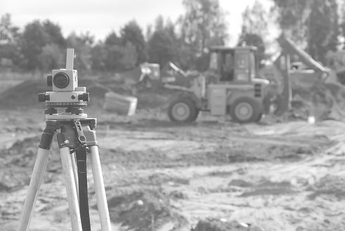
At Precise Spatial, our engineering surveying services are delivered by experienced surveyors using industry leading Leica instrumentation and advanced CAD platforms. We work across civil, structural, mechanical, and mining projects throughout Australia, providing the spatial accuracy your project demands.
What Is Engineering Surveying?
Engineering surveying encompasses the full range of survey engineering services required to successfully deliver construction and infrastructure projects. Unlike cadastral or land title surveying, engineering surveying focuses on precision measurement to support the physical build, ensuring structures, pipelines, roads, and installations are positioned exactly where design specifications require.
Key activities within engineering surveying include:
-
Setting out structures and infrastructure from design coordinates
-
Precision alignment of mechanical and structural elements
-
Pre-pour inspections to verify reinforcement and formwork prior to concrete placement
-
Construction surveying throughout all project phases
-
As-built surveys to verify completed works against design
-
Set-out and positional control across civil, structural, and mechanical disciplines

Our Engineering Survey Services
Precise Spatial offers a comprehensive suite of engineering surveying services, removing the need to engage multiple providers across a single project. Our team is equipped to support your project from ground breaking through to handover.
Construction Set-Out Surveys
Accurate set-out is the foundation of every successful build. Our surveyors translate design coordinates - working directly from AutoCAD Civil 3D, 12d Model, and Revit design files, into precise real-world positions on site, ensuring footings, columns, walls, slabs, and structural elements are placed in full compliance with engineering specifications. We provide multi-discipline set-out across civil, structural, and mechanical scopes, and work closely with pre-pour inspection workflows to maintain accuracy and documentation continuity from the earliest stages of construction through to completion.
As-Built Surveys
As-built surveys are one of the most in-demand services we provide, documenting the final position of completed works for compliance, record, and future reference. Precise Spatial captures and processes as-built data across civil, structural, mechanical, and mining projects, delivering outputs compatible with AutoCAD Civil 3D, 12d Model, and BIM environments. Deliverables typically include as-built drawings in DWG and PDF format, digital point data, and structured reports suitable for client handover, regulatory compliance, and asset management purposes. Accurate as-built records protect all parties and serve as a critical reference point throughout the life of an asset.
Pre-Pour Surveys
Pre-pour surveys are conducted prior to concrete placement to verify that reinforcement and formwork are correctly positioned in accordance with engineering drawings and tolerances. Identifying discrepancies before the pour prevents costly rectification works and protects the integrity of the completed structure. Precise Spatial provides thorough pre-pour checks with clear pass/fail reporting, giving project managers and engineers confidence before work proceeds.
Precision Alignment & Installation
Precision alignment is critical in mechanical and piping installations, industrial plant, and infrastructure where tolerance margins are tight. Precise Spatial uses high-accuracy Leica total stations; including the TS13, TS15, and TS16, to achieve sub-millimetre positioning where required. Our surveyors support SMP (Structural, Mechanical & Piping) contractors throughout installation and commissioning phases.
Civil & Infrastructure Surveys
From road alignments and drainage to bridge construction and utility corridors, our engineering surveyors provide the positional control and reporting needed to keep civil and infrastructure projects on track. We operate FIFO and drive-in drive-out (DIDO) across regional and remote project sites throughout Australia.
Structural & Geotechnical Monitoring
Structural & Geotechnical Monitoring is where monitoring is required as part of a project scope, Precise Spatial can establish and maintain survey monitoring programs for structures, excavations, embankments, and mine sites. Our surveyors set up monitoring networks, conduct observation rounds, and deliver clear reporting to engineers and project managers. This is a supporting capability that integrates with our broader engineering survey services.
Why Choose Precise Spatial?
Precise Spatial was built on the principle that clients deserve a single, capable partner across their entire surveying scope, not a fragmented mix of specialists. Here's what sets us apart:
One provider, every phase
Precision technology
Specialist expertise
We handle the full scope of engineering surveying, from initial set-out to post construction monitoring, within a single engagement: Comprehensive service offering.
Our surveyors use Leica TS13, TS15, and TS16 total stations, delivering the accuracy required for the most demanding structural and mechanical work: Industry leading Leica instrumentation
Our team has deep experience across civil, structural, mechanical, mining, and infrastructure surveying disciplines: Experienced, multidisciplinary team
No project too remote
CAD-ready outputs
We operate across all Australian states and territories, with established FIFO and DIDO capacity for regional and remote sites: Nationwide FIFO capability
All survey data is processed and delivered in formats compatible with AutoCAD Civil 3D, 12d Field, and project BIM environments: Integrated digital deliverables
Industries We Serve
Our engineering surveying services support a broad range of sectors across Australia, including:
-
Mining & Resources - underground and surface infrastructure, pit monitoring, FIFO project support
-
Civil Construction - roads, bridges, drainage, earthworks, and utilities
-
Structural & Building - commercial, industrial, and infrastructure construction set-out
-
Mechanical & Piping (SMP) - precision alignment for plant, equipment, and industrial installations
-
Renewable Energy - solar farms, wind energy infrastructure, and transmission line surveys
-
Rail - track alignment, corridor surveys, and infrastructure monitoring
Our Equipment & Technology
Precise Spatial invests in best in class survey instrumentation to ensure our clients receive the highest standard of data accuracy and reliability.
Our engineering survey toolkit includes:
-
Leica TS13, TS15 & TS16 total stations - for high precision set-out, alignment, and monitoring
-
12d Field - mobile field survey software for real time data capture and design integration
-
AutoCAD Civil 3D - industry standard CAD environment for survey calculations and deliverable preparation
-
LiDAR and UAV scanning - where 3D data capture is required alongside traditional engineering survey methods
FREQUENTLY ASKED QUESTIONS (FAQs)
What does an engineering surveyor do?
An engineering surveyor provides accurate positional measurement and spatial control to support construction and infrastructure projects. This includes setting out structures from design drawings, monitoring buildings and ground for movement, verifying completed works through as-built surveys, and supporting alignment of mechanical and structural elements throughout the build.
What is the difference between engineering engineering surveying and land surveying?
Land surveying (or cadastral surveying) deals with property boundaries, title creation, and legal land divisions. Engineering surveying focuses on construction accuracy, ensuring built structures match design intent. Both are specialist disciplines, but engineering surveying is specifically tied to the delivery and monitoring of physical infrastructure.
How accurate is engineering surveying?
Modern engineering surveying using total stations such as the Leica TS15 and TS16 can achieve positional accuracies of 1–2mm in controlled site conditions. The level of accuracy required varies by project type, structural and mechanical installations typically demand the tightest tolerances, while earthworks and civil set-out may allow broader tolerances in line with specification.
Do you operate on remote or FIFO project sites?
Yes. Precise Spatial has established FIFO and DIDO capability and regularly supports remote mining and infrastructure projects across Australia. Our team is experienced in working within site safety management plans and remote work protocols.
What deliverables will I receive from an engineering survey?
Deliverables vary based on scope, but typically include survey calculation reports, as-built drawings in DWG or PDF format, CAD data files compatible with AutoCAD Civil 3D or 12d Model, monitoring reports, and digital point data. We tailor our outputs to your project and reporting requirements.

GET IN TOUCH
Ready to Get Started?
Contact Precise Spatial today to discuss your engineering surveying requirements. Our team operates across Australia and is ready to support your next project.
JOIN THE TEAM
Visit the Careers Page, and see all current opportunities.
If there is no listing for an opportunity you are interested in, contact us with your information and resume to be considered for a future position with us.